Rule 1501:9-3-05 | Permit to construct a class II disposal well and a surface facility.


This rule applies to a new permit to construct a class II disposal well and a surface facility, a new permit to construct a class II disposal well, a new permit to convert a well to a class II disposal well and construct a surface facility, or a new permit to convert a well to a class II disposal well. A class II disposal well and a surface facility shall be designed, constructed, and operated in a manner that protects public health and safety and the environment. Compliance with this rule does not eliminate the requirement that a person comply with any other applicable laws.
(A) Area of review.
(1) The division will conduct an area of review evaluation for a proposed class II disposal well upon receipt of an application for a permit to drill, reopen, deepen, plug back, or convert a well for brine disposal. The area of review is determined in accordance with one of the following:
(a) The area of review for wells in which disposal is proposed to be less than an average volume of two hundred barrels per day per year will be the area circumscribed by a one-half mile distance from the center of the wellbore along its entire length;
(b) The area of review for wells in which disposal is proposed to be greater than an average volume of two hundred barrels but less than 1,000 barrels per day per year will be the area circumscribed by a one-mile distance from the center of the wellbore along its entire length;
(c) The area of review for wells in which disposal is proposed to be greater than an average volume of 1,000 barrels per day per year, will be the area circumscribed by a two-mile distance from the center of the wellbore along its entire length; or
(d) An area of review other than one established in paragraphs (A) (1), (A) (2), or (A) (3) of this rule may be designated by the chief.
(2) Wells in the area of review and all of available records for each well will be reviewed by the division and the applicant. A well in the area of review needs corrective action in any of the following circumstances:
(a) The wellbore penetrates the proposed injection zone or the wellbore has a total depth that is within 500 vertical feet of the top of the injection zone and was plugged in a manner not in accordance with Chapter 1501:9-11 of the Administrative Code;
(b) The wellbore penetrates the proposed injection zone or a wellbore with a total depth that is within 500 feet of the top of the injection zone is plugged with clay;
(c) The wellbore penetrates the proposed injection zone and the wellbore does not have cement on the back side of the production casing to at least 500 feet above the proposed injection zone;
(d) The wellbore has limited or no records;
(e) The wellbore penetrates the proposed injection zone or the wellbore has a total depth that is within 500 vertical feet of the of the top of injection zone and the wellbore is constructed with the production casing set with a packer; or
(f) Any other circumstance identified by the division during the record review.
(3) The applicant shall develop a list of proposed corrective actions for each well that will need corrective action. The division will review the list of proposed corrective actions, and determine which of those and any others are to be completed in order to prevent the movement of brine or other waste substances out of the permitted injection zone. Corrective action shall be completed prior to the issuance of a permit to inject.
(B) All of the following apply to the construction of a class II disposal well or conversion of a well to a class II disposal well:
(1) The division may prohibit injection into certain formations on a site-specific basis based on circumstances that may impact public health, safety, or the environment including, but not limited to, evidence of seismicity, migration of brine or other waste substances out of an injection zone, or other similar factors.
(2) For a permit to drill a new class II disposal well or to convert a well to a class II disposal well, in which the injection formation will be located in a formation that has a producing well within the area of review either of the following apply:
(a) The average disposal volume cannot exceed 200 barrels per day per year; or
(b) The class II disposal well owner must own each producing well in the area of review as long as the owner operates the class II disposal well.
(3) For a permit to drill a new class II disposal well or to convert a well to a class II disposal well in the devonian shale formation or any formation above, the average disposal volume cannot exceed 200 barrels per day per year.
(4) A person may only submit an application to convert a well to a class II disposal well if the operator of the well or the proposed well is in compliance with chapter 1509 of the Revised Code or division 1501:9 of the Administrative Code.
(C) An application for a permit includes the following:
(1) A complete application on a form(s) prescribed by the chief.
(2) Information concerning the proposed class II disposal well including:
(a) The name, description, and depth of the geological zones or formations into which injection is proposed;
(b) For a well proposed to be converted to a class II disposal well, an accurate driller's log, a mud log, any geophysical or electric log, and any testing data on the well, if available;
(c) The designation of the well by lease name and number and for conversion applications the API number;
(d) The names and addresses of all owners or operators of record of wells or permitted wells within the area of review;
(e) The name, depth, thickness, areal extent, and geological information concerning the confining zone or zones in the area of review of the proposed well, which may include the lithology, direct historical evidence, permeability, porosity, and other available geologic data that substantiates a zone's ability to confine brine or other waste substances to the permitted injection zone;
(f) A detailed description of the following:
(i) The well construction data that includes information on the casing and cementing if an existing well is to be converted, or the casing and cementing program proposed for a new well that complies with the well construction requirements established in rule 1501:9-1-08 of the Administrative Code;
(ii) The proposed method for injection that may include one or both of the following: open hole or perforations;
(iii) The proposed depth of the tubing and packer; and
(iv) The proposed stimulation program.
(g) The list of proposed corrective action of wells penetrating the proposed confining zones or injection formations within the area of review as identified in paragraph (A) of this rule;
(h) A schematic drawing that includes all of the following:
(i) Bore-hole diameter(s) and depth(s);
(ii) Outside diameter of each casing(s);
(iii) Proposed or existing placement of cement;
(iv) Location of any casing hardware;
(v) Packer depth;
(vi) Perforations/open hole;
(vii) Total depth;
(viii) Confining zone(s);
(ix) Injection zone(s); and
(x) Deepest underground source(s) of drinking water, if mapped.
(i) The proposed average volume of brine in barrels to be injected per day per year into the proposed class II disposal well, and the proposed method that will be used to measure and record the actual amount of brine injected into the well;
(j) The proposed method that will be used to continually measure and record daily injection pressures; and
(k) The proposed method to continuously monitor and to record the positive pressure in the annulus between production casing and the injection tubing;
(3) Description. A description of the proposed operations at the surface facility that includes the following, if applicable:
(a) A summary of the design flow;
(b) A summary of all containment including primary containment and secondary containment. The summary will include the volume, type, contents, and location of each primary containment. The summary will also include the calculations for each secondary containment volume;
(c) Mechanical processes;
(d) Discharge prevention measures from storage vessels and secondary containment, such as overfill protection, shut-off valves, and leak detection systems;
(e) Leak detection method for pipelines;
(f) Procedures for loading, unloading, transferring, and other means of handling of brine or other waste substances;
(g) Methods of metering and tracking the system throughput, including details on how brine will be tracked by those subject to fee(s) pursuant to division (H) of section 1509.22 of the Revised Code;
(h) Material specifications, that include, but are not limited to storage vessels, containment systems, piping, pipelines, pumps, valves, meters;
(i) A statement attesting the applicant has the right to install and maintain all pipelines;
(j) Design and construction drawings that include all of the following:
(i) A title page that contains the name of the applicant; emergency contact information to be used during construction; the county, township, and section or lot number where the proposed surface facility will be located; coordinates of the intersection of the centerline of the entrance apron at the public right-of-way using latitude and longitude, in a format of decimal degrees, to a minimum of six decimal places; and a sheet index;
(ii) A plan sheet consisting of the most recent color orthorectified aerial image known to the applicant at the time of design with pixels no larger than one foot showing the location of the proposed surface facility;
(iii) A plan sheet sealed by a professional surveyor showing the location of the proposed surface facility and the control points used to generate the map;
(iv) The scale in feet, legend, graphical scale, and north arrow;
(v) A general layout, plan views, elevations, sections, and supplementary views that in conjunction with the specifications provide the working information related to all aspects of the proposed construction, which also locate all elements horizontally in relation to the North American Datum of 1983 and vertically in relation to the North American Vertical Datum 1988;
(vi) The proposed and existing contours with an intermediate contour interval not greater than two feet and an index not greater than ten feet;
(vii) All buildings and improvements larger than 120 square feet including supporting drawings such as, electrical, plumbing, structural, and life safety;
(viii) All process piping including valves, valve locations, and types that will be used for storage;
(ix) All primary containment and secondary containment systems proposed and their capacities;
(x) All pipelines that will connect the surface facility to the class II disposal well;
(xi) All springs, wetlands, streams, lakes, rivers, ponds, and creeks which may be identified using reasonably available public resources and a field review, within two hundred feet of the storage facility;
(xii) Surface and underground mines, which may be determined using information available from the Ohio department of natural resources and other publicly available or readily accessible sources, that may affect design and performance of the proposed surface facility;
(xiii) All risk zones and hazard areas delineated on the "National Flood Insurance Rate Map" within one hundred feet of the proposed surface facility;
(xiv) Plugged wells, producing wells, idle and orphaned, and class II disposal wells that are located within one hundred feet of the storage facility. The information regarding the wells may be determined using information available from the Ohio department of natural resources and other publicly available or readily accessible sources;
(xv) All areas within one thousand five hundred feet of the proposed surface facility that are located within the five-year time of travel associated with a public drinking water supply, as delineated or endorsed under the "Source Water Assessment and Protection Program";
(xvi) All areas within one thousand five hundred feet of the proposed surface facility that are located within the emergency management zone of a public water system intake; and
(xvii) Boundaries of parcels of land, existing occupied and unoccupied structures, roadways, and existing utilities known to the applicant at the time of the design that are located within two hundred feet of the proposed surface facility.
(k) After a preoperational site review and for good cause, the chief may require any of the following as part of the permit application:
(i) Emergency release conveyance map. An emergency release conveyance map includes all of the following on a separate drawing sheet:
(A) Locations downslope of the proposed surface facility and any related pipelines where response resources may be deployed for the purposes of containment in the event of an emergency release using latitude and longitude, in a format of decimal degrees, to a minimum of six significant decimal places;
(B) Flow path and identification of nearest receiving streams, rivers, watercourses, ponds, lakes, or other bodies of water where brine or other waste substances may migrate from the proposed facility; and
(C) Pipes, ditches, and other conveyances, and hydraulic control structures identified in the storm water hydraulic report and in the sediment and erosion control plan.
(ii) Geotechnical report. A geotechnical report specific to the location of the proposed surface facility that describes the proposed facility geotechnical site conditions, design considerations that address the geotechnical conditions, and construction requirements for the proposed facility that address the geotechnical conditions and discloses the results of a surface and subsurface investigation of the proposed surface facility site. In addition, a report includes all of the following:
(A) An analysis of slope stability, bearing capacity, and settlements that have the potential to negatively impact the performance of the proposed surface facility site;
(B) Geotechnical borings or other geotechnical engineering standard investigative means, of sufficient depth and quantity to substantiate the design;
(C) An evaluation of all existing infrastructure potentially related to geotechnical considerations located within the proposed oil and gas waste facility boundary that will be used, affected or incorporated in the proposed surface facility;
(D) A summary of all subsurface exploration data specifically relevant to the geotechnical investigation and interpretation as it pertains to the design and construction of the proposed oil and gas waste facility, including subsurface soil profile, exploration logs, laboratory or in situ test results, and elevation of saturated soils at the time of exploration;
(E) An interpretation and analysis of the data required for the geotechnical report;
(F) An explanation of the geotechnical design constraints;
(G) Cross-sections through borings, critical slopes, and impacted infrastructure used in geotechnical calculations;
(H) The factor of safety for slope stability not less than 1.5 and bearing capacity not less than 3.0; and
(I) Documents showing calculations used to determine the factor of safety and a detailed explanation of each assumption and reference used in the calculations.
(iii) Sediment and erosion control plan. A sediment and erosion control plan for the proposed surface facility that describes procedures to minimize the discharge of construction related sediment to any area outside of the proposed surface facility. A plan includes all of the following:
(A) Sediment and erosion controls consistent with generally accepted engineering design criteria and controls that comply with the manufacturer's specifications;
(B) A sediment basin or sediment trap if the proposed surface facility is within or includes a total contributing drainage area that is greater than five acres in size. The minimum capacity of the sediment basin or sediment trap shall be one hundred seventeen cubic yards and designed in accordance with the "Ohio Department of Natural Resources Rainwater and Land Development Manual" as defined in Chapter 1501:9-12 of the Administrative Code;
(C) An identification of the location of each outlet of all confined discrete conveyances that may leave the proposed surface facility;
(D) A delineation of contributing drainage area boundaries and size, measured in acres; and slope, length, and percent graded, that will be used to design the proposed sediment and erosion controls;
(E) A description of the soil stabilization measures, including vegetation, mulch, and other means of controlling erosion that will be used at the proposed surface facility. In addition, a schedule of the implementation of the soil stabilization measures will be included; and
(F) The applicant may submit a schedule that identifies alternate options for implementation of the erosion and sediment controls and measures, which also identifies when and under what criteria the alternate controls would be implemented.
(4) Map. The division may request the information in the electronic format if available. A map(s) prepared by an Ohio registered surveyor including the following:
(a) The subject tract of land upon which the proposed class II disposal well is to be located and the property lines with surface and mineral owner name(s) identified;
(b) The location of the proposed class II disposal well and any related pipelines on the subject tract of land established by a field survey showing the distances in feet from the proposed well and surface facility or oil and gas waste facility to the boundary lines of the subject tract and to the nearest permanent geographic subdivision boundares;
(c) The proposed class II disposal well location designated by plane coordinates in accordance with Chapter 157 of the Revised Code. Coordinates may be established by map scale to the nearest fifty feet or by global positioning system (GPS);
(d) The location of all wells, which are within the distance of the area of review as determined under paragraph (A) of this rule. If a well or proposed well is within 200 feet of the proposed class II injection well, the distance will be marked on the map;
(e) The location of all buildings, public roads, railroads, and streams within one thousand feet of the proposed well and their distances from the proposed well;
(f) The following are to be placed in a conspicuous place on the map; the applicants name, well name, county, civil township, permanent geographic subdivisions (section, lot and/or tract) and surface elevation for the well location, USGS quadrangle name, the date the map was prepared, name of surveyor preparing the map and phone number, and map scale;
(g) If the proposed well is to be in an urbanized area, the map will only be accepted if the name of the urbanized area and the original civil township name are included;
(h) An additional color map based on aerial photography at an appropriate scale identified on the map showing the location of the well, any related pipelines, any related oil and gas waste facilities, a related surface facility, access road, and a five hundred feet radius around the well location; and
(i) Coordinates of the intersection of the centerline of the entrance apron for the class II disposal well at the public right-of-way using latitude and longitude in a format of decimal degrees to a minimum of six decimal places.
(D) Class II disposal well testing or evaluations.
(1) The chief may require the following tests or evaluations of a proposed class II disposal well in any combination that the chief deems necessary:
(a) Submittal and implementation of a plan accepted by the chief for pressure fall-off testing;
(b) Submittal and implementation of a plan accepted by the chief for geological investigation of potential faulting or fracturing in the area of review for the proposed class II disposal well location;
(c) Submittal and implementation of a plan accepted by the chief for monitoring and reporting seismic activity;
(i) The plan will require the person operating a class II disposal well to directly notify the division within 24 hours if a seismic event of 1.5 or greater magnitude occurs within three miles of the well.
(d) Testing and recording the original bottom hole injection interval pressure;
(e) Gamma ray, compensated density-neutron, and resistivity geophysical logging suite and any other log required by the chief on all newly drilled class II disposal wells. All logs shall be submitted to the division within sixty days of reaching total depth;
(f) Radioactive tracer or spinner survey;
(g) Submittal and implementation of a plan accepted by the chief for conducting a step-rate test; and
(h) Any other tests that the chief deems necessary. The applicant may request a meeting with the chief to discuss any test deemed necessary.
(2) If the chief requires the performance of tests or evaluations of a proposed class II disposal well, the applicant shall directly notify the appropriate inspector a minimum of twenty-four hours prior to performing the tests or evaluations. The chief may withhold authority to inject brine or other waste substances based upon the results of the tests or evaluations performed and may order the plugging of the well if deemed necessary.
(E) Review Procedure.
(1) General Review Procedure.
(a) After receipt of any submittal or notification of completeness for a procedure identified in figures 1, 2, and 3, the chief will review the submittal to determine if the submittal is compliant with the requirements of this rule within the times identified in figures 1, 2, and 3, as applicable. If after submittal, the chief identifies items that are necessary to ensure the submittal complies with the requirements of this rule, the chief will notify the applicant or permittee of the items that are necessary with a letter of deficiency. For any period of time specified in figures 1, 2, or 3, the date will be determined by the action of the division.
(b) The applicant or permittee may submit a revised submittal or revised portions of the submittal with an identification of all the revisions. The chief may require the resubmission of the entire submittal. If the applicant or permittee has not submitted the revised submittal or revised portions of the submittal in accordance with the times established in figure 1, 2, and 3, as applicable, the chief may issue an order denying the application. The chief will review the revised submittal or revised portions of the submittal in accordance with the times established in figures 1, 2, and 3, as applicable. The chief may approve a longer period of time for any of the revised submittal or site review times established in figures 1, 2, and 3, as applicable, upon written request by the applicant or permittee.
(c) If the applicant or permittee has not submitted documents compliant with this rule within three hundred sixty-five calendar days of issuance of the initial letter of deficiency, the application is terminated.
(d) After completing the review of all submittals, the chief will either issue a permit or deny the issuance of the permit by order.
(i) The chief may deny an application if the chief determines the applicant did not substantiate a zone's ability to confine brine or other waste substances to the permitted injection zone.
(e) The chief may require the applicant or permittee to submit additional information pertaining to the design and construction of the proposed or permitted class II disposal well and surface facility, that the chief determines is necessary for the protection of public health or safety or to prevent damage to the environment or is necessary to ensure compliance with the requirements of this rule.
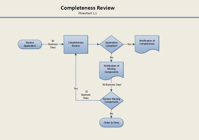
(2) The chief will review the application for the class II disposal well and surface facility in accordance with figure 1 to determine if the application is a complete application. When the chief determines that the application is complete, the applicant will be notified in writing.
Figure 1
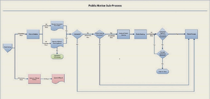
(3) Public Notice Process. The chief may combine multiple applications from the same applicant on the same subject tract into a single public notice process
(a) Within fifteen business days after the chief's determination that an application for a permit for a class II disposal well is ready for notice as established in figure 3, the division will provide public notice of the application by posting the application on the division's website.
(b) Within fifteen business days after the chief's determination that an application for a permit for a class II disposal well is ready for notice as established in figure 3, and the division provides the notice of application to the applicant, the applicant shall provide notice of application in each of the following formats:
(i) Provide by hand delivery or certified mail a notice of application to all of the following:
(A) All owners or operators of wells within the area of review identified in paragraph (A)(1) of this rule;
(B) The owner of each parcel of real property that is located within one thousand five hundred feet of the proposed class II disposal well. For the purposes of determining the identity of each owner of a parcel of real property as of the date of the notice of application, the applicant may use the tax records of the county auditor of each county in which a parcel of real property is located; and
(C) The board of county commissioners and the board of township trustees or the executive authority of a municipal corporation where the proposed class II disposal well is to be located.
(ii) Published in a newspaper of general circulation in the county in which the proposed well is located either for five consecutive days or two consecutive editions of a weekly newspaper.
(iii) The applicant shall submit an affidavit attesting to the delivery and date of delivery to those entitled to notice of application, and the proof of publication and publication dates in accordance with paragraph (E)(3) of this rule. The affidavit of delivery of notice will be submitted on a form prescribed and provided by the division and will include a list of all persons notified in paragraph (E)(3) of this rule. The applicant shall retain copies of proof of notification and publication for a period of up to two years and be made available to the chief upon request.
(c) Comments and objections.
(i) Any person desiring to comment or to make an objection with reference to an application for a permit under this rule shall file such comments or objections, in writing, with the division of oil and gas resources management, 2045 Morse Road, building F, Columbus, Ohio 43229 or electronically through the division of oil and gas resources management website. In order for a comment or an objection to be reviewed by the chief, the comment or the objection must be filed with the division no later than thirty calendar days from the date of the posting of the public notice on the division's website and include the name and mailing address of the person making the comment or objection.
(ii) Before the end of the public comment period as established in this rule, any person receiving notification in paragraph (E)(3)(b) of this rule may request a public meeting. The division will hold a meeting, at a location and in a format to be determined by the chief. The division will provide notice of the public meeting at least thirty calendar days prior to the meeting. The notice will provide the date, time, format, and location of the public meeting via a posting on the division's website. The division also will provide the same notice to the applicant. Only those comments provided at the meeting, orally or in writing, will be reviewed by the chief. If the chief receives no requests for public meeting within the established public comment period, no meeting will be held.
(iii) The chief will review all received comments and objections within sixty calendar days after the end of the comment period or within forty-five calendar days after the conclusion of the public meeting to determine if the comments raise any legal deficiency or technical deficiency in the application related to Chapter 1509 of the Revised Code or division 1501:9 of the Administrative Code or to determine if the comments are outside the jurisdiction of Chapter 1509 of the Revised Code or division 1501:9 of the Administrative Code. If the chief determines no deficiency exists or if the comments are outside the jurisdiction of Chapter 1509 of the Revised Code or division 1501:9 of the Administrative Code, the public notice process is complete. The chief, in a manner to be determined by the chief, will respond to comments received from any person receiving notification in paragraph (E)(3)(b) of this rule and make the responses available on the website of the division. If the chief determines a comment or objection identifies a legal deficiency or technical deficiency in the application, the chief may address the legal or technical deficiency by issuing a permit subject to terms or conditions or the application will be returned to the applicant for correction of any deficiency within thirty calendar days.
(iv) Upon submittal of a revision to an application, including any deficiency, the chief will determine if all or any portion of paragraph (E)(3) of this rule is to be repeated by the applicant.
(4) Technical Review. The chief will perform a technical review of the application for a permit for a class II disposal well in accordance with the times established in figure 2 to determine if the application for the proposed class II disposal well complies with the requirements of this rule.
Figure 2
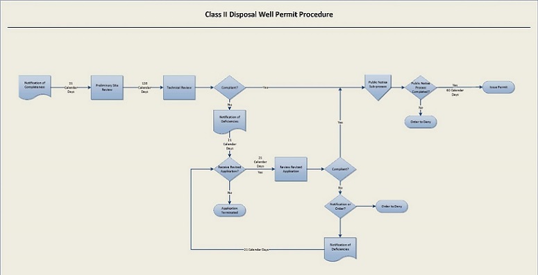
Figure 3
Last updated January 13, 2022 at 10:01 AM
Supplemental Information